San Francisco · Self-guided audio walk

The Waterfront Reclaimed

A flat, bay-hugging promenade from the Ferry Building to Ghirardelli Square, tracing what opened up when the Embarcadero Freeway came down.

  • 7Stops
  • 4.9 kmDistance
  • 70+ minTime
The Waterfront Reclaimed

Photo by Leo_Visions on Unsplash

Until 1991, a double-decker freeway ran right here, cutting San Francisco off from its own bay. The Loma Prieta earthquake shook it loose, and the city made a choice: tear it down and face the water again. This walk follows the palm-lined Embarcadero that replaced it, from the 1898 Ferry Building clock tower to the chocolate-scented bricks of Ghirardelli Square. It is entirely flat, about two and a half miles, and built for stopping. You pass a wooden pier that stretches 840 feet over the bay, a science museum cooled by seawater, and the docks where sea lions have barked since 1990. Give yourself around ninety minutes; longer if the food hall pulls you in.

Hear it on the street

Get the turn-by-turn audio guide in the app. The narration plays itself as you reach each stop, hands-free and offline.

Stop by stop

The route

Interactive map of the route. The full stop list below works without it.

Ferry BuildingMust see

Photo by CeeCee Weaver on Unsplash

Ferry Building

0:00

The 1898 Beaux-Arts ferry terminal with its 245-foot clock tower, now a food hall devoted to Northern California growers and producers.

You are standing in front of the Ferry Building, whose clock tower has been the first thing arriving ferries saw since 1898. Architect A. Page Brown gave it a 245-foot tower, four clock faces each 22 feet across, and a long arched arcade that once funneled forty-seven million passengers a year at its peak. For decades the Embarcadero Freeway loomed right over this spot, two decks of concrete that blocked the building from the city and the city from the bay.

After the 1989 Loma Prieta earthquake damaged it beyond repair, the freeway came down in 1991. The building reopened in 2003 with the ground floor turned into a marketplace: cheese from Marin, oysters from Tomales Bay, bread baked that morning. The clock mechanism is the original E. Howard Special Number 4 from Boston, once the largest wind-up mechanical clock in the world.

It runs on an electric motor now, but the huge weight and sixteen-foot pendulum are still in there, motionless. Walk through the arcade when you are ready. The next stop is half a mile north.

≈8 min walk to the next stop
Pier 7Local pick

Photo by Luis Aleman on Unsplash

Pier 7

0:00

An 840-foot wooden pier with ornamental ironwork and benches, framed by the Bay Bridge and the Transamerica Pyramid.

You are on Pier 7, which runs 840 feet into the bay on timber decking. The city rebuilt it in 1990 after the Loma Prieta earthquake, but a Pier 7 has stood at this spot since 1901. The old one handled cargo and passenger ships; the new one was designed for walking and fishing, with ornamental iron handrails and old-style lampposts. Look back toward land.

The Transamerica Pyramid rises straight ahead, and the Bay Bridge arcs across the water to your right. At the end of the pier the water is about thirty-five feet deep. Fishermen come here for halibut and striped bass, and on a clear day you can see Alcatraz. When you are ready, head back to the Embarcadero and keep walking north.

≈5 min walk to the next stop
ExploratoriumLocal pick

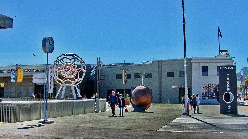
Photo by }{enry on Openverse

Exploratorium

0:00

The hands-on science museum founded by Frank Oppenheimer in 1969, now in a net-zero-energy home on the bay at Pier 15.

The Exploratorium moved here to Pier 15 in 2013, into a hundred-year-old pier shed nearly three football fields long. Frank Oppenheimer, a physicist who worked on the Manhattan Project before being blacklisted in the 1950s, started the museum in 1969 at the Palace of Fine Arts. His idea was simple: people learn science by touching it. The new building runs on 5,874 rooftop solar panels and cools itself with bay water pumped through a heat exchanger.

That alone saves two million gallons of water a year. Step into the free outdoor gallery if you like. There are exhibits that let you dial up your own rainstorm and a camera obscura that throws an upside-down view of the bay onto a table. The indoor museum is worth a full afternoon, but even the public spaces outside give you a taste.

When you are done, continue north.

≈24 min walk to the next stop
Free preview ends here · stops 4 to 7 continue in the app

Pier 39

The pier where California sea lions took over K-Dock after the 1989 earthquake and never left.

in app

Hyde Street Pier

Part of the San Francisco Maritime National Historical Park, with a fleet of historic ships including the 1886 square-rigger Balclutha.

in app

Aquatic Park

A curved cove protected by a long municipal pier, with a small beach, cold-water swimmers, and a clear view of Alcatraz.

in app

Ghirardelli Square

The former Ghirardelli chocolate factory, now a shopping and dining complex with the original brick buildings from the 1860s.

in app
Good to know

Before you go

What happened to the Embarcadero Freeway?

The Embarcadero Freeway was a double-decker concrete highway that ran along the waterfront from the Bay Bridge to Fisherman's Wharf, cutting the city off from its bay for nearly 40 years. The 1989 Loma Prieta earthquake damaged it beyond repair. The city voted to tear it down rather than rebuild it. The palm-lined promenade, the Ferry Building's revived role as a public food hall, and the entire waterfront neighborhood you walk today are what replaced it. The freeway came down in 1991.

Are the sea lions at Pier 39 always there?

California sea lions took over K-Dock at Pier 39 shortly after the 1989 earthquake and never left. Their numbers peak in winter and early spring, when over a thousand animals can haul out. In summer, many migrate south to breed in the Channel Islands, but a smaller group stays year-round. The viewing platform at the western end of the pier is free.

Provenance · last verified August 18, 2026

Built from the Wayside route itself: the stops, their order, and the walk between them.

Photo by Leo_Visions on Unsplash

Photo by CeeCee Weaver on Unsplash

Photo by Luis Aleman on Unsplash

Photo by }{enry on Openverse · CC BY 2.0

Photo by Mike McBey on Wikimedia Commons · CC BY 2.0

Photo by Adam Dillon on Unsplash

Photo by Dietmar Rabich on Wikimedia Commons · CC BY-SA 4.0

Photo by Cedric Letsch on Unsplash

Photo by Ligocsicnarf89 on Wikimedia Commons · CC BY 4.0

Photo by Steven Lek on Wikimedia Commons · CC BY-SA 4.0

Photo by Ken Lund from Reno, Nevada, USA on Wikimedia Commons · CC BY-SA 2.0

Coming soon

Wayside isn't in the app stores yet, but it's in the works. Check back soon.