Brussels · Self-guided audio walk

Matongé & Saint-Boniface

An hour through Brussels' African quarter and the neo-Gothic streets beside it: hairdressers and wax fabric, Congolese kitchens, then Art Nouveau façades and café terraces. Ten minutes from the Royal Quarter, it feels like another city.

  • 7Stops
  • 1.8 kmDistance
  • 30+ minTime
Matongé & Saint-Boniface

Photo by Varech on Wikimedia Commons

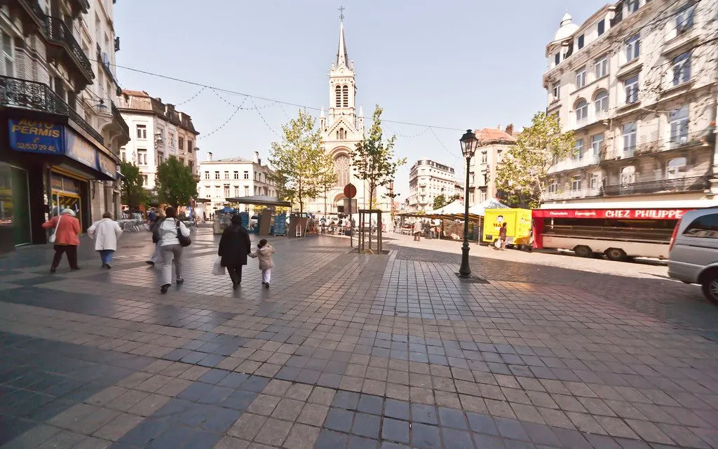
Matongé is a triangle of streets around the Porte de Namur, named after a district of Kinshasa. Congolese students gathered at the Maison africaine from the late 1950s, African shops followed from the late 1970s, and the galleries that had emptied out for the shopping centre at Louise filled up again with hairdressers, cosmetics counters and cafés.

This walk stays inside that triangle, then crosses into the older quarter next door. You go through the two covered galleries, along the Chaussée de Wavre with its wax fabric traders and grocers, and down Rue Longue Vie past Congolese and Senegalese kitchens.

Then the street names change. Saint-Boniface church is a few minutes away, ringed by the Art Nouveau houses Ernest Blérot built in 1900, and Place Fernand Cocq keeps its terraces full.

Come in the afternoon, and reach the church early if you want to go inside. Sunday morning the quarter is quiet.

Hear it on the street

Get the turn-by-turn audio guide in the app. The narration plays itself as you reach each stop, hands-free and offline.

Stop by stop

The route

Interactive map of the route. The full stop list below works without it.

Porte de NamurMust see

Photo by Tram93 on Wikimedia Commons

Porte de Namur

0:00

Where the old city gate opened onto Ixelles, and Matongé begins.

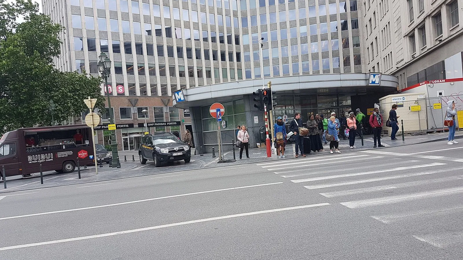
You're standing at the Porte de Namur, the gate that used to open the city of Brussels onto the plain of Ixelles. When the second set of ramparts came down in the 1860s, the gate became a square, and the streets behind it filled with the shops and cafés you're about to walk through. The line between the city of Brussels and the commune of Ixelles runs right through this crossroads.

Look for a mural on a façade nearby. Chéri Samba, a painter from Kinshasa, made it in 2002, and it became the quarter's emblem almost at once. It came down for building works in 2006 and went back up on a neighbouring wall in 2010.

That mix is the story of this walk: an ordinary Brussels junction that turned into the African quarter of the city, with the old street plan still underneath. The name Matongé came from the people who worked and shopped here, from a district of Kinshasa, and for years no map carried it. The commune only started using the name itself after 2000.
≈4 min walk to the next stop
Galerie MatongéLocal pick

Photo by Mellonne on Wikimedia Commons

Galerie Matongé

0:00

Two covered galleries linking the main streets, renamed after the quarter in 2017.

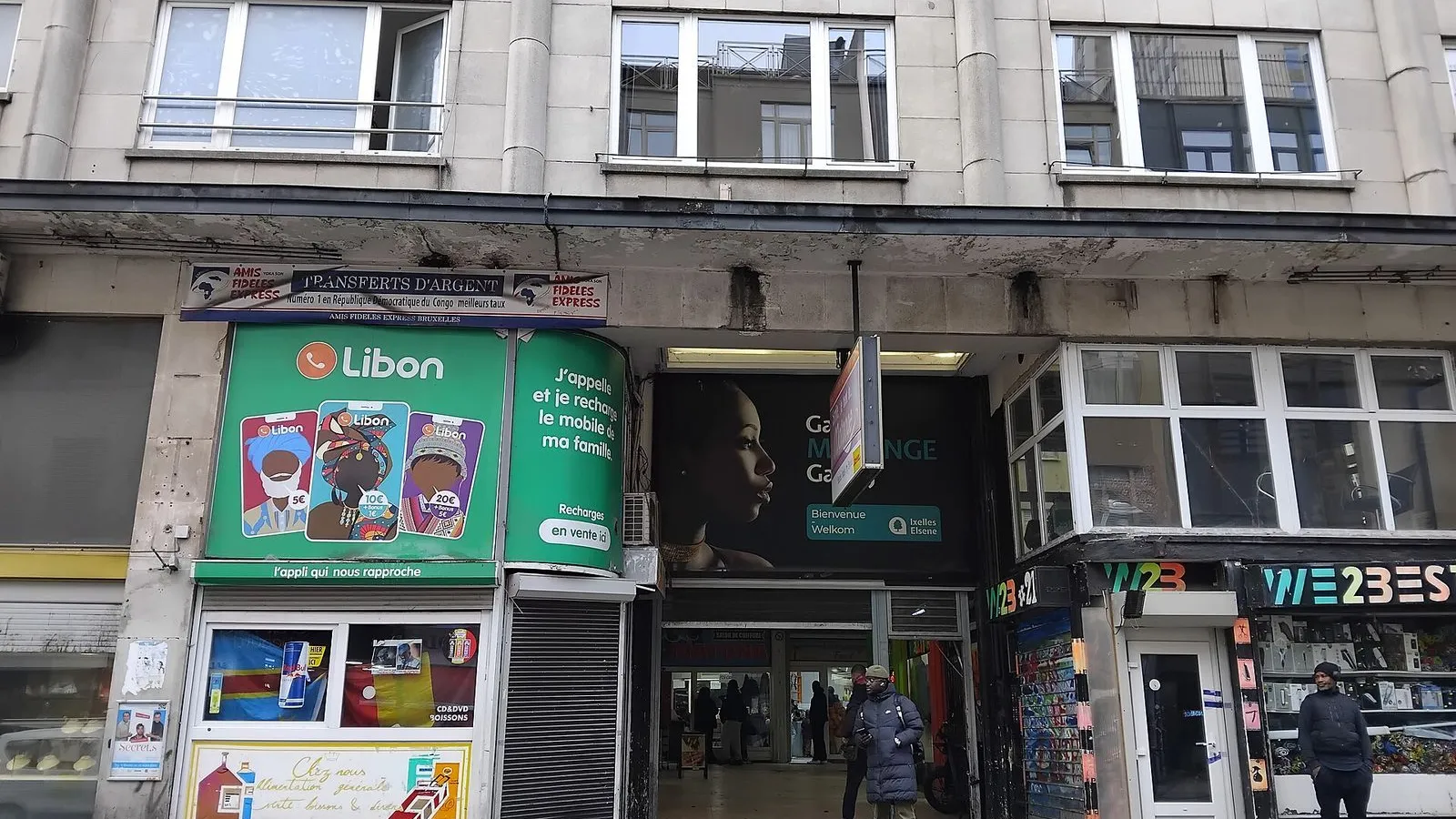
Step inside. The Galerie de la Porte de Namur brought you here from the square; the Galerie Matongé is the one you're standing in, and it runs the short block between the Chaussée d'Ixelles at number 48 and the Chaussée de Wavre at number 19.

It opened in 1953 as the Nouvelle Galerie d'Ixelles, designed by the architect Jean-Florian Collin, with a cinema, offices, flats and two levels of parking underground. For a while it was one of the smart addresses of Ixelles. Then the big shopping centre opened at Louise and the Belgian shopkeepers moved out one by one through the late 1970s.

What replaced them is what you see: hairdressing salons, cosmetics counters, small shops and bars. The first African hairdresser opened here in 1977, the first café in 1980. Locals have their own names for these two passages, Kanda-Kanda for this one and Inzia for the other, and the official renaming to Galerie Matongé only came in 2017. Ask anyone standing in a doorway and they'll tell you which is which.

≈7 min walk to the next stop
Chaussée de WavreLocal pick

Photo by Benoît Prieur on Wikimedia Commons

Chaussée de Wavre

0:00

Wax print by the metre, tropical groceries, and money transfer windows.

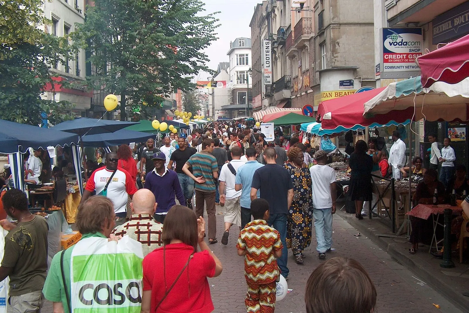
Chaussée de Wavre is the artery, and it does two jobs at once. Back toward the Porte de Namur, it's where you buy cloth: rolls of wax print in the doorways, sold by the metre and by the half roll, with customers who drive in from the Netherlands and northern France to stock up. That trade is what gave the quarter its name. Zaïre lifted its ban on imported wax fabric in the early 1980s, wholesalers moved in along this street, and it was those traders, not the city, who started calling the district Matongé.

Walk a little further and the shops change again. Grocers stack cassava, plantain, smoked fish and palm oil. There are cosmetics counters, braiding salons, money transfer windows and travel agencies, and crates of tropical fruit and vegetables set out on the pavement. Chez Mère Malou, at number 104, has been cooking Congolese dishes here since 1996, and La Boule Bleue, a few doors on, serves an African buffet. Nothing is staged for visitors. This is a working shopping street, and it fills up in the afternoon and early evening.

≈2 min walk to the next stop
Free preview ends here · stops 4 to 7 continue in the app

Rue Longue Vie

Short street of Congolese and West African kitchens, open late.

in app

Église Saint-Boniface

One of Brussels' first neo-Gothic churches, at the end of the street.

in app

Rue Saint-Boniface

Cafés and the Art Nouveau houses Blérot built here in 1900.

in app

Place Fernand Cocq

Café terraces on a square remade around them.

in app
Good to know

Before you go

When should I walk Matongé?

An afternoon suits it best: the shops and galleries are open and you can reach Saint-Boniface early if you want to go inside. Sunday morning the quarter sleeps, and evenings belong to the kitchens and the terraces.

Where should I eat?

Rue Longue Vie is the street for it, with Congolese and West African kitchens that cook late; Thieyp at number 46 serves a couple of dishes each day and fresh house juices.

SourceLa souris globe-trotteuse, where to eat in Brussels
Why is the quarter called Matongé?

Matongé is named after a district of Kinshasa: Congolese students gathered at the Maison africaine from the late 1950s, and African shops filled the streets from the late 1970s.

Keep exploring

More walks in Brussels

Mont des Arts & the Royal QuarterThe essentials

Mont des Arts & the Royal Quarter

Brussels is a city on two levels. This walk climbs from the cathedral to the palace plateau, past a gallery that hides a whole floor, a garden built over a car park, and a square laid over a palace that burned in 1731.

7 stops1.9 km30+ min
Brussels in ComicsThe local mix

Brussels in Comics

Brussels put comics on its walls. More than fifty of them since 1991, when the city peeled off its advertising hoardings and painted over the damage. One loop from Horta's comic museum to the Gauls of Rue de la Buanderie.

8 stops2.7 km45+ min
Sablon & the MarollesThe local mix

Sablon & the Marolles

Two markets, one hill. Up top, chocolate and antiques at weekend prices. A few streets down, the daily brol of the Marolles. Time it for a market morning and the contrast is the whole walk.

8 stops2.5 km40+ min
Cinquantenaire Park & its MuseumsThe essentials

Cinquantenaire Park & its Museums

One esplanade, three museums, a park and a rooftop more than 60 meters above Brussels. Cars, marble, aircraft and a bronze chariot keep this walk interesting when the sky gives way.

5 stops1.1 km20+ min
Grand-Place & the Lower TownThe local mix

Grand-Place & the Lower Town

A first walk through the heart of Brussels: a glass-roofed arcade, the square rebuilt in stone after 1695, and the old harbour quays where the city's fish market once stood.

8 stops1.8 km30+ min
Ixelles Ponds, Flagey & Art NouveauThe local mix

Ixelles Ponds, Flagey & Art Nouveau

On foot from a Wednesday market square to a Cistercian abbey, along the valley the Maelbeek cut: Horta's first house, the ponds, and a street of facades you read from the pavement.

8 stops3.4 km55+ min
Saint-Gilles: Horta & the ParvisThe local mix

Saint-Gilles: Horta & the Parvis

A walk south of the centre through the streets where Belgium's Art Nouveau was built, covered in sgraffito you have to look up to see, and nearly lost, ending on the market square the neighbourhood still lives on.

8 stops4.1 km60+ min

Provenance · last verified September 27, 2026

Built from the Wayside route itself: the stops, their order, and the walk between them.

Photo by Varech on Wikimedia Commons · CC BY-SA 3.0

Photo by Tram93 on Wikimedia Commons · CC BY-SA 4.0

Photo by Mellonne on Wikimedia Commons · CC0

Photo by Benoît Prieur on Wikimedia Commons · CC0

Photo by TE LUN OU YANG on Unsplash

Photo by Ferran Cornellà on Wikimedia Commons · CC BY-SA 3.0

Photo by Flocci Nivis on Wikimedia Commons · CC BY 4.0

Photo by MJJR on Wikimedia Commons · CC BY 3.0

Photo by Virginia Marinova on Unsplash

Photo by Jopparn on Wikimedia Commons · CC BY-SA 3.0

Photo by infomatique on Openverse · CC BY-SA 2.0

Coming soon

Wayside isn't in the app stores yet, but it's in the works. Check back soon.